
Groundwater & Aquifers
Relied on most in at least 11 of 22 Arab states, according to UNESCO and UN-Water, and the least visible: fossil aquifers, falling water tables, salinity and the recharge schemes trying to slow the decline.
Why it matters
Groundwater is the region’s least visible water resource. According to UNESCO and UN-Water, it is the most relied-upon source in at least 11 of the 22 Arab states, a wider grouping than the twenty countries covered here, and it supplies more than 80% of freshwater withdrawals in Libya, Djibouti, Saudi Arabia and Palestine.1 Unlike a river, nobody can see it. Unlike a reservoir, nobody can easily measure what is left.
The satellite record puts hard numbers on the decline. NASA’s GRACE mission measured 143.6 km³ of fresh water lost across the Tigris and Euphrates basin and western Iran in the seven years from 2003 to 2009, nearly a Dead Sea’s worth. Roughly two-thirds of it, 91.3 ± 10.9 km³, came out of groundwater, at 17.3 ± 2.1 mm a year of equivalent water height against a total storage loss of 27.2 ± 0.6 mm a year.2 It remains the clearest single measurement of a region spending its buffer.
Much of this water is not renewable on any human timeframe. The Nubian sandstone was filled in the Pleistocene, and its recharge today is described as effectively zero, so pumping it is closer to mining than to harvesting.3 Saudi fossil water in the north is about 20,000 years old, and rainfall of 100 to 200 mm a year does not replace it.4 For the Gulf states as a group, depletion of non-renewable groundwater has been estimated at 317% of the renewable volume.1
In many places the renewable aquifers, the coastal and alluvial systems, are drawn down faster than rainfall replaces them, which pulls seawater inland and pushes salinity up.1 Richey et al. (2015) name the Arabian Aquifer System and the Murzuk-Djado Basin as the most overstressed of the 37 large aquifers on their GRACE-based measure; the Nubian and North Western Sahara systems are also overstressed.5
For companies and lenders, this is a market defined by measurement and remediation. It covers drilling and well-field rehabilitation, monitoring and metering, managed recharge, brackish desalination, and the modelling work behind abstraction licences and transboundary negotiations.
State of the region
Four systems dominate the map. The Nubian Sandstone Aquifer System, among the largest bodies of fresh water on earth, underlies Egypt, Libya, Sudan and Chad and feeds Libya’s Great Man-Made River.6 7 The North Western Sahara Aquifer System, NWSAS in English and SASS in the French literature, is shared by Algeria, Tunisia and Libya.7 The Saq-Ram aquifer system, also known as Disi, runs under Saudi Arabia and Jordan and supplies Amman through a 325 km conveyor.8 9 The Umm er Radhuma and Dammam limestones stretch beneath most of the Gulf peninsula, and the regional inventory maps them as three separate sections rather than one.10 11 12
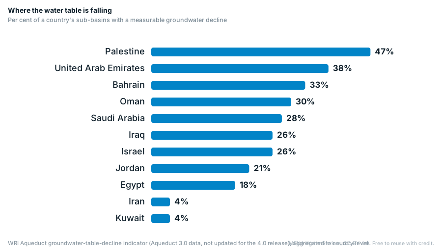
Where the water table is falling
Per cent of a country's sub-basins with a measurable groundwater decline
Sources and notes
WRI Aqueduct groundwater-table-decline indicator (Aqueduct 3.0 data, not updated for the 4.0 release), aggregated to country level.
The systems, and what is known about them
The region’s major aquifer systems, largest first. Where the regional inventory and IGRAC delineate the same system differently, both figures are shown.
| System | Countries | Extent, km² | IGRAC extent, km² | Recharge | What the inventory records |
|---|---|---|---|---|---|
| Nubian Sandstone (NSAS) | Chad, Egypt, Libya, Sudan | 2,000,000 | 2,450,101 | Recharge effectively zero | About 540,000 km³ stored, of which some 15,340 km³ is thought exploitable. |
| North Western Sahara (NWSAS, SASS) | Algeria, Libya, Tunisia | 1,000,000 | 1,041,019 | About 1 bn m³/yr | Abstraction reached 2.5 bn m³/yr in 2000, against 0.6 bn in 1970, from roughly 8,800 water points. |
| Saq-Ram (Disi) | Jordan, Saudi Arabia | 308,000 | 151,718 | 2 to 20 mm/yr | Storage 4 to 10 bn m³ in Jordan against about 740 bn m³ in Saudi Arabia; Saudi abstraction above 1,000 MCM/yr. |
| Umm er Radhuma-Dammam, south (Rub al Khali) | Oman, Saudi Arabia, UAE, Yemen | 680,000 | 686,619 | Very low to low (0 to 20 mm/yr) | Reported abstraction of 45 MCM/yr in Oman and 7.7 MCM/yr in the UAE. |
| Umm er Radhuma-Dammam, centre (Gulf) | Bahrain, Qatar, Saudi Arabia | 281,000 | 291,613 | Very low to low (0 to 20 mm/yr) | Average abstraction of 97 MCM/yr from the Dammam in Bahrain (2010) and 54.3 MCM/yr from its Umm er Radhuma (2006), 91 MCM/yr in Qatar (1983) and about 608 MCM/yr in Saudi Arabia (2006) has left the system open to salinisation. IGRAC's delineation also lists the UAE. |
| Umm er Radhuma-Dammam, north (Widyan-Salman) | Iraq, Kuwait, Saudi Arabia | 246,000 | 242,966 | Very low to low (0 to 20 mm/yr) | Water levels have fallen by up to 60 m in both formations. |
| Coastal Aquifer Basin | Egypt, Israel, Palestine | 18,370 | 18,945 | 350 to 375 MCM/yr from rainfall | The 2013 inventory cites a sustainable yield of 360 to 420 MCM/yr for the Gaza and Israeli sections, of which about 15% (some 55 MCM) is in Gaza, and Gaza abstraction of 150 to 180 MCM a year. |
| Basalt, south (Azraq-Dhuleil) | Jordan, Syria | 8,500 | 8,457 | Renewable | Abstraction of 15 to 20 MCM/yr in the north; the Azraq springs stopped flowing after a well field opened in 1980. |
| Basalt, west (Yarmouk basin) | Jordan, Syria | 7,000 | 6,873 | Renewable | Groundwater provisions sit inside the 1987 Yarmouk river agreement rather than in an aquifer treaty. |
| Nile Delta aquifer | Egypt | 30,000 | – | Renewable, and salinising | About 4,050 bn m³ in place to the hydrogeological base; the main Pleistocene layer thickens from 200 m in the south to 1,000 m in the north. |
Sources and notes
Sources: UN-ESCWA and BGR, Inventory of Shared Water Resources in Western Asia (2013), groundwater chapters; Observatoire du Sahara et du Sahel (2008) for the North Western Sahara; the Joint Authority figures for the Nubian Sandstone; Mabrouk et al. (2018) for the Nile Delta volume; IGRAC, Transboundary Aquifers of the Middle East and of Africa (2022) for the delineated extents. The two extent columns disagree because they map different things, and a storage figure for a fossil system is a stock estimate, not water available for use.
The four systems, and the state of each
Nubian Sandstone: the largest, and the one being spent
About 540,000 km³ of water is thought to be stored, of which some 15,340 km³ is considered exploitable, across an area the Joint Authority puts at 2 million km² and IGRAC delineates at 2.45 million.6 13 Recharge today is effectively zero.3
Libya’s network is about 4,500 km long and supplies more than 70% of its urban areas. In December 2024 a report said the project was entering its fifth and final phase, described it as a US$7 billion initiative and put its total cost at US$25 billion.14
Saq-Ram, also known as Disi
Sandstone running under Saudi Arabia and Jordan, supplying Amman through a 325 km conveyance since 2013 at 100 million cubic metres a year from a field of 55 wells, under a 25-year build-operate-transfer concession.9 15
The asymmetry is the point. Jordan holds 4 to 10 billion cubic metres of the system against Saudi Arabia’s 740 billion, recharge is 2 to 20 mm a year, and Saudi abstraction near Tabuk rose from about 29 million cubic metres a year in 1983 to between 1,050 and 1,700 million by 2004, against recharge of 3 to 10 million.8 It is also a bridge rather than a supply, which is why Jordan spent the years it bought building a carrier from the sea.
Umm er Radhuma and Dammam: the Gulf’s shallow reserve, turning brackish
Three mapped sections, not one. The southern section under Oman, Saudi Arabia, the UAE and Yemen covers about 680,000 km²; the central section under Bahrain, Qatar and Saudi Arabia about 281,000; the northern section under Iraq, Kuwait and Saudi Arabia about 246,000, where water levels have fallen by up to 60 metres in both formations.10 11 12
Average abstraction of 97 million cubic metres a year from the Dammam in Bahrain (2010) and 54.3 million from its Umm er Radhuma (2006), 91 million in Qatar (1983) and about 608 million in Saudi Arabia (2006) has left the central section open to salinisation.11 Seawater intrusion has been reported up to 8 km inland on Oman’s north-west coast.16 Abu Dhabi stores desalinated water in the Liwa Strategic Water Reserve, in a dune aquifer, which is storage rather than abstraction.17
North Western Sahara: shared by Algeria, Tunisia and Libya
Over 1 million km², of which 700,000 in Algeria, 80,000 in Tunisia and 250,000 in Libya, recharged by only about 1 billion cubic metres a year.7 IGRAC lists the system with two riparians rather than three.13
Abstraction rose from 0.6 billion cubic metres a year in 1970 to 2.5 billion in 2000, about two and a half times annual recharge, drawn from roughly 8,800 water points. Agriculture is the major water consumer.7
The renewable aquifers, which are the ones actually failing
Coastal and alluvial systems do recharge, but in many places they are drawn down faster than rainfall replaces them. That pulls seawater inland and pushes salinity up.1
Morocco’s Souss is the clearest measured case: piezometer 859/62 in the upstream Souss fell 1.9 metres a year between 1998 and 2008 and 3.5 metres a year between 2012 and 2020, while the correlation between the rainfall index and the standardised water-level index across the Souss and Massa is 0.07, which points at pumping rather than drought.18 In Iraq’s Sinjar and Ba’aj districts, where groundwater is the only source, more than 75,000 people in Wardiya, Solagh, Tal Banat and Tal Qasab face shortages, rainfall has fallen 40% in five years and 15% of residents have already migrated.19
Case study
One case in this sector, examined in full.
Interactive dashboard
The hub's headline metric for all twenty countries. Hover, tap or focus a country; the ranked table sits alongside.
Enable JavaScript to load the dashboard.
Sources and notes
Share of a country's river sub-basins where WRI Aqueduct records a significant declining groundwater trend (≥2 cm a year). Aqueduct 3.0 data, not updated for the 4.0 release of 2023; blank where the dataset reports no significant trend. The Golan Heights have been occupied by Israel since 1967; UN Security Council resolution 497 (1981) declared Israel's decision to impose its laws, jurisdiction and administration there null and void. Shown as a separate area, bounded by dashed lines. The area as drawn includes the Shebaa Farms, which Lebanon claims; the UN Secretary-General reported in 2000 that these farmlands lie in the area of operations of the UN Disengagement Observer Force and in an area occupied by Israel since 1967 (S/2000/460, paragraph 17). Golan outline: GADM, as carried by WRI Aqueduct 4.0.
Where the decline is measured
Four independent measurement methods now cover the region: satellite gravity for whole aquifers, piezometric records for national totals, radar interferometry for the ground surface, and well logs for individual basins. They agree on direction and differ on magnitude, which is worth saying plainly rather than averaging away.
North Africa, from satellite gravity
Between 2003 and 2016 the Nubian system lost around 50 km³ and the North Western Sahara more than 30 km³. The Nubian loss is attributable to abstraction alone; the North Western Sahara loss is part climate and part abstraction, and the nearby Tindouf basin, which tracks rainfall closely, lost under 10 km³.20 Depletion rates have been put at 6.08 ± 1.9 km³ a year for the Nubian and 2.69 ± 0.8 for the Sahara, against non-satellite estimates of 2.17 km³ for the Nubian, for 2000, and more than 2.2 km³ for the Sahara.21
Iran, from well records and radar
Piezometric records across 478 sub-basins give a loss of about 74 km³ between 2002 and 2015, some 5.25 km³ a year, with extreme overdraft across roughly 77% of the land area.22 These are well records, not gravity measurements, so they cannot be added to GRACE totals. A separate radar study puts annual depletion from confined and semiconfined aquifers at about 1.7 billion cubic metres.23
The ground is following the water down. Sentinel-1 interferometry for 2014 to 2020 makes Rafsanjan the fastest-sinking place in the country at 37 cm a year, ahead of Arzuiyeh at 34, Savojbolagh at 29 and Nazarabad at 27, with subsidence hazard across 56,000 km², 3.5% of Iran, where more than 14 million people live.23 Mashhad has the longest record and the clearest pairing of cause and effect: a water table down 65 metres over four decades, and vertical deformation of about 19 cm a year.24
Egypt and Saudi Arabia
For Egypt, GRACE gives depletion of 0.64 ± 0.03 cm a year over Sinai and 0.32 ± 0.03 over the Nile Delta aquifer between 2003 and 2021, with about 7.25 km³ taken from the Nubian in the Western Desert. Losses from the Moghra aquifer rose roughly eightfold across the same period, from 32 to 262 million cubic metres a year.25
Saudi Arabia’s total water storage fell 7.94 ± 0.22 mm a year from 2002 to 2016. The Saq is where the methods genuinely conflict: the same study reports a significant negative storage trend over the aquifer and a positive recharge estimate of 4.65 ± 0.10 km³ a year, so no single clean figure for the Saq can responsibly be quoted.26 Storage under the northern desert is put at 252 to 870 km³, and hydrologists expect only about 50 more years of economic pumping, which is why the wheat programme was phased out from 2008 and ended in 2016.4
Jordan, Morocco and Yemen, from the basin records
Six of Jordan’s twelve basins were pumped at 146 to 235% of safe yield; Azraq’s four main springs had dried out by 1992, and its water table had fallen about 25 metres over 28 years, while safe yield was revised from 20 to 24 million cubic metres a year.27 A 2015 ministry account put national abstraction at 625 million cubic metres from 3,138 known licensed and unlicensed wells, more than double the 275 million safe yield. Well monitoring for 2010 showed average declines of about a metre a year across six basins, and 9 metres at the worst single well.28
Morocco’s aquifers run at 100% of recharge in the Moulouya to 248% in Chtouka-Massa, with Tadla, Souss, Haouz and Saïss between 150 and 170%; national withdrawals of about 5 billion cubic metres exceed renewable groundwater by 28%.29 30 Levels have dropped 20 to 65 metres across all basins in 30 years.29
In Yemen a 2010 estimate put the annual fall in groundwater levels at about six metres in the Sanaa basin, against two and a half to four and a half in many other areas, and by 2019 western Yemen had reached its lowest level in the satellite record, which began in 2002.31 32 Well counts disagree: about 100,000 mostly illegal wells were estimated for Sanaa and its surroundings alone, while the World Bank estimated that 100,000 tube wells might exist nationwide.32 31
Sources and notes
One caveat applies to the dashboard above. The World Resources Institute did not update its groundwater-table-decline indicator for the Aqueduct 4.0 release, so that layer reflects older data.33 The time to 90% depletion depends on the assumed storage as well as the depletion rate: for the North Western Sahara system, estimates range from about 10 years to 150,000 years under different storage estimates.21
Quality: salinity & contamination
Quantity and quality fail together. As a water table drops, older and saltier groundwater moves into what was the fresh part of the aquifer.34 Coastal aquifers draw seawater inland to replace what was pumped. Shallow aquifers also take in nitrate from fertiliser and sewage from unsewered districts.35
Gaza is the extreme case. Some 97% of the water extracted from its coastal aquifer is unfit for human consumption against WHO standards, because the only aquifer has been depleted by over-extraction and contaminated by sewage and seawater.36 37 A survey of 115 municipal wells found chloride averaging 1,419 mg/L and peaking at 9,491, nitrate averaging 112 mg/L against a WHO guideline of 50, and fluoride up to 2.6 mg/L.35 In the 2017 monitoring round only about one well in nine met the nitrate limit and one in five the chloride limit, and salinity has risen by a third in twenty years while nitrate shows no clear trend.38
On the Gulf coast the same process is measured in kilometres. At Al-Qatif in eastern Saudi Arabia the shallow aquifer runs from 4,220 to 34,090 mg/L of dissolved solids, averaging 10,108, with the intrusion front about 3.5 km inland.39 In the multi-layered aquifers of the same Qatif area, dissolved solids range from 1,955 to 15,560 mg/L.40 On the Libyan coast intrusion was already estimated to be advancing 100 to 250 metres a year in FAO’s 1997 regional survey.41
In the northeastern Nile Delta the salt has reached the soil. Electrical conductivity across surveyed fields runs from 0.53 to 49.7 dS/m and averages 22.2, with 42.8% of soil samples strongly saline and 21.4% very strongly saline, over shallow groundwater of 837 to 34,900 mg/L sitting half a metre to three metres below the surface.42 Modelling the seawater wedge is harder than it looks: a steady-state model can misplace its top and toe by up to 10 km compared with a palaeohydrogeological reconstruction.43
Nitrate and fluoride show up in local studies rather than in a regional assessment. On the Angads plain near Oujda in Morocco, nitrate runs from 7 to 171 mg/L and nearly half of samples exceed the WHO limit.44 Globally about a tenth of fluoride measurements exceed 1.5 mg/L, and across 15% of Africa’s land area the probability of exceeding it is above one in two; in Iran’s Bushehr province every monitored station averaged above the guideline, from 1.52 to 3.64 mg/L.45 46
Seawater intrusion
The characteristic failure of coastal aquifers from Gaza and the Nile Delta to Libya's coast and Oman's Batinah. It can be pushed back: recharging effluent from Salalah's central sewage treatment plant through wells along the coast has been credited with reducing seawater intrusion from 3.4 km to 2.7 km.
Nitrate and sewage
Unsewered urban expansion and fertiliser leach into shallow aquifers that households then pump for drinking. In Gaza's municipal wells nitrate averages more than twice the WHO guideline, which is why sanitation investment is also groundwater-quality investment.
Salinisation of soil
Irrigating with brackish groundwater in a high-evaporation climate leaves salt behind in the root zone. Salinity can reduce yields and require additional water to leach salts from the root zone. FAO's survey of Iraq found 4% of the irrigated area severely saline, 50% medium and 20% slightly, and the northeastern Nile Delta shows the same build-up.
Sources and notes
Sources for the case files: Parimalarenganayaki (2020) on the Salalah recharge scheme47; Shomar and Rovira (2023) on Gaza’s municipal wells35; FAO, Irrigation in the Near East region in figures (1997), for the Iraqi salinity shares48; FAO’s Water quality for agriculture on yields and leaching49; the 2024 Scientific Reports survey for the Nile Delta.42
Recharge & storage
The engineering response is managed aquifer recharge: deliberately putting water underground when it is available and taking it out when it is not.50
Abu Dhabi’s Liwa reserve, and what is actually proven
The scheme holds more than 26 million cubic metres of desalinated water in a dune aquifer, filled from the Shuweihat plant at 32,000 cubic metres a day over 27 months, with some 315 recovery wells reaching 80 metres, completed at the end of 2017, with the completion reported in January 2018, at about US$435 million.17 50 Gulf News reported it as enough to give one million people 180 litres a day for up to 90 days.51 The launch publicity gave a fallback pumping capacity of 100 million gallons a day;17 TRANSCO’s planning statement gives a design recovery of 40 million gallons a day.52 Earlier figures in circulation are 17 million cubic metres injected in 2012 and a 23 million target, which is worth knowing before quoting any single volume.34 53
A recovery efficiency of 88% is widely quoted.47 What is documented is the pilot, where recovery through the wells around the infiltration basin worked without problems and the recovered water most likely met Abu Dhabi’s drinking water standards.50 No published account covers a full-scale recovery cycle, so treat 88% as a claim rather than a demonstrated result.
Recharge dams, which are the region’s largest MAR programme by count
At the end of February 2026 Oman’s ministry oversaw 209 dams. Its surface-storage and groundwater-recharge dams had a combined capacity of about 458.7 million cubic metres and had impounded more than 3.17 billion cubic metres of floodwater by the end of 2025; a December 2024 ministry statement put the total at 191 dams and 357.7 million cubic metres.54 55 56 In 2014 the stock was 89 surface retention dams, 45 purpose-built recharge dams and 14 flood protection dams, all built since 1985, and assessments in Dhofar showed recharge efficiency of up to 75%.57
Saudi Arabia has 522 dams with 2.3 billion cubic metres of capacity, of which 1.6 billion is utilised, for runoff collection, storage and recharge.58 The UAE’s AQUASTAT register lists 68 dams built between 1982 and 2004, including Al Tawiyeen at 18.5 million cubic metres; at the Wurayah and Tawyeen dams, 20 to 40% of stored water was measured as reaching the aquifer.59 47
Reuse to recharge, where it exists
Bahrain has recharged the Khobar aquifer with treated effluent since 1986.60 Oman injects treated wastewater in a managed way in exactly one place, Salalah, where the recharge has been credited with reducing seawater intrusion from 3.4 to 2.7 km.57 47 Tunisia recharged 20 of 28 targeted aquifers with 38.4 million cubic metres in 2011, 92% of it from hill dams and only 4% from treated wastewater, under a policy that ran experimentally from the 1970s and structurally from 1992.61
Gulf aquifer storage and recovery work with published numbers includes Kabd in Kuwait, recovering 100,000 cubic metres a day from eight wells at 77% efficiency, and a pilot test at Nizwa that found the aquifer could hold 400 million imperial gallons.47 Qatar is often listed alongside them, but the peer-reviewed work there is a siting study rather than infrastructure, identifying zones that could hold up to 182.8 million cubic metres if a scheme were built.62
Abu Dhabi holds more than 26 million cubic metres of desalinated water in a dune aquifer, enough for one million people at 180 litres a day for up to 90 days.
Projects & tenders
The tracked projects in this sector and the structured procurements coming next, straight from our databases.
Projects
Sources and notes
Only a handful of tracked projects are primarily groundwater schemes. That is the market, not a gap in the database: the region's capital pipeline is dominated by desalination and reuse, and groundwater is mostly abstracted through dispersed private wells that no tender register captures.
Rules at the wellhead
Most countries in the region have a system of licences or permits for groundwater use, though applying it has proven difficult in practice.63 Almost none measures what comes out of them, and fewer still charge for it. The gap between the statute book and the wellhead is where groundwater policy actually fails.
- Iran: of about 416,000 authorised agricultural wells, roughly 125,000, or about 30%, carry volumetric smart meters
- Jordan: By-law 85 of 2002 licenses drilling, rigs and abstraction, but the first 150,000 cubic metres a year from a licensed agricultural well remain free of charge
- Morocco: aquifer contracts have a legal basis in Article 115 of Law 36-15, but by the state auditor's 2018 review only one had been signed against a target of ten
- Oman: 180,444 wells and 4,198 aflaj are registered, and meters have effectively never been installed beyond pilots
- Abu Dhabi: Law 6 of 2006 licenses drilling and over 80,000 wells are permitted, but farm metering was dropped after landowner resistance
- Tunisia: authorisation is required only below 50 metres, and the 9,300 deep boreholes counted in 2010 had no meters, so declared volumes cannot be checked
Iran shows the measurement gap at its largest. Of about 416,000 authorised agricultural wells, roughly 125,000 carry volumetric smart meters, about 30%. Since the Fair Water Distribution Law, at least 15 annual laws and medium-term programmes have obliged the Ministry of Energy to implement volumetric water delivery to farms.64
Jordan has a documented enforcement record. More than 1,293 illegal wells had been backfilled or capped by 2016, 644 of them by June 2015, alongside 1,228 notices, halted rigs and stopped excavators, with meter-installation compliance reaching 95%; up to 159 drilling rigs had been confiscated by April 2015.28 63 The pricing, though, still exempts the first 150,000 cubic metres a year from a licensed farm well: measuring without charging.28
Morocco shows the other failure mode, which is an instrument that exists on paper. The aquifer contracts rest on Article 115 of the 2016 water law, piloted on Souss and Mnasra from 2007 and codified after an interministerial circular in November 2013; by the Cour des comptes’ review only the Souss contract had been signed against ten targeted by the end of 2018, the implementing decree was unpublished, Chtouka was the only gazetted safeguard zone, and more than 102,264 abstractors were operating outside the authorisation regime altogether.65 66 Metering, a key Souss measure, was postponed.63
The older statutes already provide for permits and meters. Oman declared its groundwater public wealth by royal decree in 1988 and required registration and permits from 1990, with power to set permissible discharge and require flow meters; the well inventory that followed registered more than 167,000 wells, and the law on meters was never effectively applied.57 54 Egypt has required a ministry permit to dig any well since Article 46 of Law 12 of 1984, for no more than ten years at a time.60 Saudi Arabia regulated drilling permits by executive order in 1989 for farms above 2.5 hectares.60 In Algeria’s Wilaya of Blida, on the Mitidja plain, 2,000 illegal wells sit alongside 1,200 legal ones.60 Abu Dhabi prosecuted 34 illegal-drilling cases in 2012 and 87 in 2013, and issues about 1,750 new well permits a year.34
Shared aquifers & governance
Enable JavaScript to load the interactive map; the full list is below.
All 50 aquifers, with the countries that share them
Select a name to find it on the map; small ones are easier to reach from here.
- Iran, Turkmenistan
- Algeria, Morocco
- Lebanon, Syria
- Israel, Jordan
- Algeria, Morocco
- Jordan, Syria
- Jordan, Syria
- Algeria, Morocco
- Egypt, Israel, Palestine
- Libya, Tunisia
- Israel, Palestine
- Israel, Lebanon
- Algeria, Morocco
- Greece, Turkey
- Algeria, Morocco
- Afghanistan, Iran, Turkmenistan
- Syria, Turkey
- Afghanistan, Iran
- Algeria, Tunisia
- Algeria, Cameroon, Central African Republic, Chad, Niger, Nigeria
- Armenia, Turkey
- Azerbaijan, Iran
- Bulgaria, Turkey
- Azerbaijan, Iran
- Iraq, Syria
- Iraq, Kuwait, Saudi Arabia
- Algeria, Libya, Tunisia
- Israel, Palestine
- Chad, Egypt, Libya, Sudan
- Bulgaria, Greece, Turkey
- Jordan, Saudi Arabia
- Iran, Turkmenistan
- Egypt, Israel
- Algeria, Chad, Libya, Niger
- Algeria, Benin, Mali, Niger, Nigeria
- Algeria, Burkina Faso, Mali, Mauritania
- Iran, Iraq, Turkey
- Jordan, Saudi Arabia
- Afghanistan, Iran
- Algeria, Mauritania, Morocco
- Bulgaria, Turkey
- Afghanistan, Iran
- Bahrain, Qatar, Saudi Arabia, United Arab Emirates
- Iraq, Kuwait, Saudi Arabia
- Oman, Saudi Arabia, United Arab Emirates, Yemen
- Iraq, Syria, Turkey
- Saudi Arabia, Yemen
- Iraq, Saudi Arabia
- Saudi Arabia, Yemen
- Israel, Palestine
50 transboundary aquifer systems reach into the twenty countries covered here, each shared by two or more states, drawn in full, including the parts outside those countries. Hover or tap an aquifer for the countries that share it.
Sources and notes
IGRAC and UNESCO-IHP, Transboundary Aquifers of the World, 2025 edition. Countries sharing each outline as the sources list them (IGRAC's UN names and TFDD's country names; the West Bank shown as Palestine, Western Sahara counted with Morocco; disputed areas TFDD lists as separate units are not counted as countries). Outlines drawn whole and cropped only at the map frame. Country outlines as on the Region Atlas. The Golan Heights have been occupied by Israel since 1967; UN Security Council resolution 497 (1981) declared Israel's decision to impose its laws, jurisdiction and administration there null and void. Shown as a separate area, bounded by dashed lines. The area as drawn includes the Shebaa Farms, which Lebanon claims; the UN Secretary-General reported in 2000 that these farmlands lie in the area of operations of the UN Disengagement Observer Force and in an area occupied by Israel since 1967 (S/2000/460, paragraph 17). Golan outline: GADM, as carried by WRI Aqueduct 4.0.
Almost every major aquifer here crosses a border, and almost none is governed by a binding sharing agreement. IGRAC’s current global map, the 2025 edition, identifies 426 transboundary aquifers, with 49 new, 41 revised and 91 removed since the previous edition.67 For the Arab region specifically, 42 transboundary aquifer systems cover almost 58% of the land area, and every Arab state except the Comoros draws on at least one.1 Across Africa, cooperation had been formalised for seven transboundary aquifers by 2018.68
The regional inventory is blunt about the record. Its 26 chapters, nine on surface water and 17 on groundwater, conclude that there are no specific agreements on shared groundwater resources in Western Asia, though a few bilateral agreements include groundwater provisions.69 That was written in 2013, which is what makes the next paragraph the exception.
Disi, 2015: the one operational aquifer agreement
Signed in Riyadh on 30 April 2015 and in force from the date of signature. It creates a protected area of about 400 km² on each side of the border, requires the elimination within five years of all activities there that depend on extracting groundwater, adds a management area of roughly 1,000 km² each side limited to municipal abstraction, and is reviewed every 25 years.70 15 The agreement works with survey markers rather than a fixed width, so the “10 km each side” figure in press coverage should not be repeated.
Nubian Sandstone: an authority, and data sharing
Egypt and Libya created a joint authority in 1989 and adopted its constitutive agreement in 1992, seated in Tripoli; Sudan joined in 1996 and Chad in 1999.6 71 Two further instruments on monitoring and the exchange of groundwater information followed in October 2000, and all four water ministers signed a Regional Strategic Action Plan on 18 September 2013.71 6 None of these instruments sets national allocations.
North Western Sahara: a mechanism without a treaty
There is no treaty. A procès-verbal was endorsed separately by Algeria on 6 January 2003, Tunisia on 15 February and Libya on 23 February.72 Options agreed at FAO headquarters in December 2002 led through Algiers and Tunis in 2005 to the creation of a consultation mechanism and its secretariat at the Sahara and Sahel Observatory in November 2007.7
The Mountain Aquifer: interim arrangements, thirty years on
Governed by Article 40 of Annex III to the Oslo II agreement of 28 September 1995, under which Israel recognised Palestinian water rights in the West Bank to be negotiated in permanent status talks, a Joint Water Committee was created for the interim period, future Palestinian needs were estimated at 70 to 80 million cubic metres a year, and 28.6 million a year was to be made available.73 The interim period has outlasted the arrangement.
Joint bodies for shared aquifers
Five bodies or arrangements manage or coordinate aquifers shared by the twenty countries covered here. The table lists what the sources opened for this page confirm.
| Body | Aquifer | Member countries | Founding instrument and year | What it does |
|---|---|---|---|---|
| Joint Authority for the Study and Development of the Nubian Sandstone Aquifer Waters | Nubian Sandstone Aquifer System | Chad, Egypt, Libya, Sudan | Constitution of the Joint Authority, 1992. Egypt and Libya set the Authority up in 1989; Sudan joined in 1996 and Chad in 1999. | Seated in Tripoli. Collects and analyses data from the member states, studies water quantity and quality, develops common policies and programmes, and may ration consumption. Two instruments on monitoring and data sharing followed in October 2000, and a Regional Strategic Action Plan was signed on 18 September 2013.71 6 |
| NWSAS Consultation Mechanism, coordinated by the Sahara and Sahel Observatory (OSS) | North Western Sahara Aquifer System | Algeria, Libya, Tunisia | Technical structure agreed in 2002 and endorsed in 2003; ministerial declaration, 2005; configuration and funding defined, June 2007. A convention was signed in Algiers on 24 April 2024. | A steering committee of the national water bodies, a coordination unit housed at the OSS in Tunis and an ad hoc scientific committee. Maintains the common database and model, sets up joint monitoring networks and identifies transboundary problems; the three states share the funding equally. Algeria ratified the 2024 convention by presidential decree 24-379 of 27 November 2024.7 72 74 |
| Joint Saudi/Jordanian Technical Committee | Al-Sag/Al-Disi aquifer | Jordan, Saudi Arabia | Agreement signed in Riyadh on 30 April 2015, in force from signature. | Five members from each side, meeting every six months. Supervises implementation, observes the quantity, quality and level of abstraction, and exchanges information. The agreement is reviewed every 25 years.70 |
| Joint Water Committee | West Bank groundwater, including the Mountain Aquifer (the committee’s remit covers all West Bank water and sewage) | Israel, Palestine | Oslo II Interim Agreement, 28 September 1995, Annex III, Article 40, for the interim period. | An equal number of representatives from each side; decisions by consensus. Handles coordinated management of water resources, dispute resolution and monitoring, with detailed duties set out in Schedule 8.75 |
| ITTAS Consultation Mechanism, supported by the OSS | Iullemeden and Taoudeni/Tanezrouft Aquifer Systems | Algeria, Benin, Burkina Faso, Mali, Mauritania, Niger, Nigeria | Memorandum of understanding signed in Abuja on 28 March 2014; it enters into force 30 days after ratification by two thirds of the member states. | Provides for a council of ministers, an executive secretariat, a permanent scientific and technical committee and national committees, and gives the mechanism legal personality. The OSS describes it as in a transitional phase, with a transitional coordination unit hosted by the OSS (third meeting, Tunis, 18 to 19 December 2025).76 77 |
Sources and notes
Method. Each row was checked against the founding text or an organisation page read in full, listed in the numbered sources: the Nubian authority against IW:LEARN and the International Water Law Project; the North Western Sahara mechanism against the OSS synthesis, IW:LEARN and the Algerian Journal Officiel; the Disi committee against the 2015 agreement (unofficial English translation); the Joint Water Committee against the National Academies reproduction of the Oslo II excerpts; and the ITTAS mechanism against the 2014 memorandum and the OSS meeting page. Not verified. The text of the 2024 North Western Sahara convention was not read, so its terms and whether it is in force for all three states are not stated here. Ratification of the ITTAS memorandum was not found; Algeria is not among the attendees named in the OSS report of its December 2025 meeting. The Joint Water Committee is not an aquifer body in the strict sense: its remit is all West Bank water and sewage, and the aquifer name is the usual one for the shared groundwater, not a term in the excerpt. Bodies for aquifers outside the twenty countries, such as the Guarani and Stampriet arrangements, are left out. No other joint body for a shared aquifer involving these countries was found in the sources opened.
Our Region Atlas maps the transboundary aquifer systems (IGRAC) alongside river basins and infrastructure.
Business opportunities
Where the commercial and donor activity concentrates:
Monitoring & metering
Regulators cannot cap what they cannot measure. Potential areas for investment include telemetry on wells, satellite-gravity and InSAR subsidence monitoring, and national groundwater information systems.
Managed aquifer recharge
Design, construction and operation of recharge dams, infiltration basins and injection well-fields, sometimes paired with reuse, as at Salalah and in Bahrain.
Brackish desalination
Desalinating brackish groundwater costs less than desalinating seawater: in Jordan, annualised reverse-osmosis costs were put at US$0.65 a cubic metre for brackish groundwater against US$1.7 for seawater.
Well-field rehabilitation
Deepening, relining and re-equipping ageing well-fields, plus the pump and drilling services that go with them.
Hydrogeological modelling
Aquifer characterisation and numerical modelling underpin abstraction licensing, DFI appraisals and transboundary negotiations.
Solar pumping controls
Solar irrigation cut costs but removed the fuel-price brake on pumping; metering and control systems that pair with solar address that gap.
Key organisations
The bodies that commission, regulate or deliver in this sector, and the names that recur across its tenders.
- Ministry of Environment, Water & Agriculture (MEWA)Ministry · Saudi Arabia
- Ministry of Water & Irrigation (MWI)Ministry · Jordan
- Environment Agency – Abu Dhabi (EAD)Environment · United Arab Emirates
- Hydraulic Basin Agencies (ABH, ×10)Basin & resources authority · Morocco
- UN-ESCWARegional body · Regional
Mandates, procurement routes and the rest of the region’s institutions are in the decision-maker directory.
Outlook
The direction of travel is not in doubt. What is genuinely uncertain is the timetable, and the uncertainty sits in storage rather than in depletion: for the North Western Sahara system, the time to 90% depletion ranges from about a decade to 150,000 years depending on which storage estimate is used.21 In Saudi Arabia, hydrologists cited by the USGS expect pumping of the fossil water under the irrigated desert to stay economical for only about another 50 years.4
The encouraging signal is that the biggest users have started acting. Saudi Arabia ended its wheat programme to save groundwater, Abu Dhabi banks desalinated water underground, and Jordan protects the Disi zone by treaty.4 17 70 The discouraging signal is that solar pumping has removed the fuel-cost brake on abstraction, exactly where governance is weakest, and has the potential to exceed what diesel ever pumped.32
Strategic storage has also acquired a security argument. Desalination supplies about 90% of Kuwait’s drinking water, 86% of Oman’s and 70% of Saudi Arabia’s, and in early March 2026 reported strikes damaged desalination plants in both Bahrain and Iran, and Iran’s foreign minister said water supply in 30 villages had been affected.79 80 Groundwater management here is now less a hydrological problem than an institutional one.
Further reading
Standing references for this sector.
- IGRAC, Global Groundwater Information System. The transboundary aquifer inventory, and the polygons behind the aquifer maps on this site. un-igrac.org
- Transboundary Waters Atlas, the shared-basin and shared-aquifer reference this site links to for every cross-border system. transboundarywatersatlas.org
- FAO AQUASTAT, the standing database of national water resources, withdrawals and irrigated area. The denominator behind most figures on this site. fao.org
Sources
80 references
- UNESCO and UN-Water (2022), World Water Development Report 2022: Groundwater, facts and figures.
- Voss, K.A. et al. (2013), “Groundwater depletion in the Middle East from GRACE with implications for transboundary water management in the Tigris-Euphrates-Western Iran region”, Water Resources Research 49, full text via PubMed Central.
- Eos (AGU), “Ancient water underlies arid Egypt”, 18 June 2019.
- USGS EROS, Earthshots: Fossil Water, and “Saudi wheat experiment relied on fossil water”, 21 November 2016.
- Richey, A.S. et al. (2015), “Quantifying renewable groundwater stress with GRACE”, Water Resources Research 51, author copy via eScholarship.
- International Water Law Project, “Adoption of a regional strategic action plan on the Nubian Sandstone Aquifer”, 20 October 2013.
- Observatoire du Sahara et du Sahel (2008), The North-Western Sahara Aquifer System (Algeria, Tunisia, Libya), Synthesis No. 1.
- UN-ESCWA and BGR (2013), Inventory of Shared Water Resources in Western Asia, chapter 10: Saq-Ram aquifer system.
- U.S. International Development Finance Corporation, Disi Water: non-confidential project information.
- UN-ESCWA and BGR (2013), Inventory of Shared Water Resources in Western Asia, chapter 14: Umm er Radhuma-Dammam aquifer system, south.
- UN-ESCWA and BGR (2013), Inventory of Shared Water Resources in Western Asia, chapter 15: Umm er Radhuma-Dammam aquifer system, centre.
- UN-ESCWA and BGR (2013), Inventory of Shared Water Resources in Western Asia, chapter 16: Umm er Radhuma-Dammam aquifer system, north.
- IGRAC (2022), Transboundary Aquifers of Africa map, and Transboundary Aquifers of the Middle East map.
- The Middle East Observer, “Libya’s Great Man-Made River project nears completion”, 10 December 2024.
- International Water Law Project, “The newest transboundary aquifer agreement: Jordan and Saudi Arabia cooperate over the Al-Sag/Al-Disi aquifer”, 31 August 2015.
- “Water resources availability, sustainability and challenges in the GCC countries” (2023), Heliyon 9(10), full text via PubMed Central.
- WaterWorld, “World’s largest man-made desalinated water reserve completed in Abu Dhabi”, 22 January 2018.
- Gouahi, S. et al. (2025), “Assessment of groundwater drought risk in arid regions”, Frontiers in Water, doi:10.3389/frwa.2025.1628691.
- United Nations in Iraq, “Rain brief: recent rainfall and water situation in Iraq”, 5 June 2026.
- Mohamed, A. et al. (2020), “Groundwater storage changes in the major North African transboundary aquifer systems during the GRACE era (2003–2016)”, Water 12(10):2669, doi:10.3390/w12102669.
- Richey, A.S. et al. (2015), “Uncertainty in global groundwater storage estimates in a Total Groundwater Stress framework”, Water Resources Research 51, author copy via eScholarship.
- Ashraf, S., Nazemi, A. and AghaKouchak, A. (2021), “Anthropogenic drought dominates groundwater depletion in Iran”, Scientific Reports 11: 9135, full text via PubMed Central.
- “Uncovering the impacts of depleting aquifers: a remote sensing analysis of land subsidence in Iran” (2024), Science Advances, full text via PubMed Central.
- Dehghani, M. et al. (2020), “Extreme subsidence in a populated city (Mashhad) detected by PSInSAR”, Scientific Reports, full text via PubMed Central.
- “Satellite-based estimates of groundwater storage depletion over Egypt” (2023), Environmental Monitoring and Assessment, full text via PubMed Central.
- Alghamdi, A. et al. (2022), “Application of time-variable gravity to groundwater storage fluctuations in Saudi Arabia”, Frontiers in Earth Science, doi:10.3389/feart.2022.873352.
- IWMI and USAID, Groundwater Governance in the Arab World, Report No. 12: the Azraq basin, Jordan.
- IWMI and USAID, Groundwater Governance in the Arab World, Report No. 11: Jordan.
- Bahir, M. et al. (2020), “Moroccan groundwater resources and evolution with global climate changes”, Geosciences 10(2):81, copy via IRD.
- World Bank (2023), Morocco CCDR background note: water scarcity and droughts.
- UNDP (2022), A holistic approach to addressing water resources challenges in Yemen.
- Conflict and Environment Observatory, “Groundwater depletion clouds Yemen’s solar revolution”, April 2021.
- World Resources Institute, Aqueduct 4.0 data FAQ (2023).
- IWMI and USAID, Groundwater Governance in the Arab World, Report No. 13: Abu Dhabi.
- Shomar, B. and Rovira, J. (2023), “Human health risks associated with the consumption of groundwater in the Gaza Strip”, Heliyon 9(11), full text via PubMed Central.
- UN OCHA, occupied Palestinian territory, “Study warns water sanitation crisis in Gaza may cause disease outbreak”, 16 November 2018.
- UN-ESCWA (2023), War on Gaza: weaponizing access to water, energy, food and land.
- “Drinking water access and quality in the Gaza Strip prior to 7 October 2023 and implications for reconstruction” (2025), Environmental Health, full text via PubMed Central.
- “Integrated hydrogeological, hydrochemical and isotopic assessment of seawater intrusion in Al-Qatif” (2022), Molecules 27(20):6841, full text via PubMed Central.
- “Effects of seawater intrusion on the groundwater quality of multi-layered aquifers in eastern Saudi Arabia” (2023), Molecules, full text via PubMed Central.
- FAO (1997), Irrigation in the Near East region in figures: Libya.
- “Monitoring soil salinization and waterlogging in the northeastern Nile Delta linked to shallow saline groundwater and irrigation water quality” (2024), Scientific Reports, doi:10.1038/s41598-024-77954-x.
- “A three-dimensional palaeohydrogeological reconstruction of the groundwater salinity distribution in the Nile Delta aquifer” (2019), Hydrology and Earth System Sciences 23, doi:10.5194/hess-23-5175-2019.
- “Assessment of groundwater pollution using the PIG index in the Angads plain, Morocco” (2025), Scientific Reports, full text via PubMed Central.
- Podgorski, J. and Berg, M. (2022), “Global analysis and prediction of fluoride in groundwater”, Nature Communications, full text via PubMed Central.
- “Data on fluoride contents in groundwater of Bushehr province, Iran” (2018), Data in Brief, full text via PubMed Central.
- Parimalarenganayaki, S. (2020), “Managed aquifer recharge in the Gulf countries: a review and selection criteria”, Arabian Journal for Science and Engineering 46, full text via PubMed Central.
- FAO (1997), Irrigation in the Near East region in figures: Iraq.
- FAO, Water quality for agriculture, chapter 2: salinity problems.
- GRIPP and IWMI, “A strategic water reserve in Abu Dhabi”, August 2018.
- Abdul Kader, B., Gulf News, “Abu Dhabi completes world’s largest desalinated water reserve”, January 2018 (page last updated 5 November 2018).
- TRANSCO, 2019 Seven Year Water Planning Statement (2020–2026), Rev. 1, 31 October 2019, section on the water supply scheme for the Aquifer Project (Contract G-4877): infiltration of 7.0 MIGD and recovery of 40.0 MIGD for emergency supply. Copy hosted by Saudi Gulf Projects.
- “Modeling aquifer storage and recovery in the eastern district of the United Arab Emirates using MODFLOW” (2022), Scientific Reports, full text via PubMed Central.
- Oman Observer, “Oman reaffirms commitment to water resource sustainability”, 21 March 2026.
- Oman Observer, “Beyond water: the true value of Oman’s dams”, 18 July 2026.
- Oman Observer, “Oman has 191 water dams”, 7 December 2024.
- IWMI and USAID, Groundwater Governance in the Arab World, Report No. 14: Oman.
- Alwazir, A. (2022), Saudi Arabia’s water sector, US-Saudi Business Council.
- FAO AQUASTAT, Dams of the United Arab Emirates (register, 2008 profile).
- IWMI and USAID, Groundwater Governance in the Arab World, Report No. 1: taking stock and addressing the challenges.
- IWMI and USAID, Groundwater Governance in the Arab World, Report No. 7: Tunisia, December 2016.
- “GIS-based framework for artificial aquifer recharge to secure sustainable strategic water reserves in Qatar” (2021), full text via PubMed Central.
- Molle, F., Closas, A. and Al-Zubari, W. (2017), “Governing groundwater in the Middle East and North Africa region”, in Advances in Groundwater Governance, CRC Press, chapter 26, pp. 532 and 542.
- Tehran Times, “25% of agricultural water wells equipped with smart meters”, 11 August 2026.
- Cour des comptes (Morocco), Gestion du domaine public hydraulique, annual report for 2018.
- Finances News Hebdo, “Les contrats de nappe, entre acquis mitigés et contraintes”, 6 November 2022.
- IGRAC, “New Transboundary Aquifers of the World Map 2025 is available for download”.
- Nijsten, G.-J., Christelis, G., Villholth, K.G., Braune, E. and Gaye, C.B. (2018), “Transboundary aquifers of Africa: review of the current state of knowledge and progress towards sustainable development and management”, Journal of Hydrology: Regional Studies, doi:10.1016/j.ejrh.2018.03.004.
- UN-ESCWA and BGR (2013), Inventory of Shared Water Resources in Western Asia, information brochure.
- Agreement between Jordan and Saudi Arabia for the management and utilisation of ground waters in the Al-Sag/Al-Disi layer, signed 30 April 2015, unofficial English translation.
- IW:LEARN, legal frameworks: Nubian Sandstone Aquifer System.
- IW:LEARN, legal frameworks: North Western Sahara Aquifer System.
- Oslo II Interim Agreement, 28 September 1995, Annex III Article 40, excerpts reproduced in National Academies Press (1999), NCBI Bookshelf NBK230239.
- Journal Officiel de la République algérienne no. 80, 4 December 2024, presidential decree no. 24-379 of 27 November 2024 ratifying the convention establishing a consultation mechanism on shared groundwater of the northern Sahara, signed in Algiers on 24 April 2024 (decree text only; the convention text is not published there).
- National Academy of Sciences (1999), Water for the Future: The West Bank and Gaza Strip, Israel, and Jordan, Appendix B: excerpts from the Israeli-Palestinian Interim Agreement (signed 28 September 1995), Annex III, Article 40, paragraphs 11 to 15. National Academies Press, doi:10.17226/6031.
- Sahara and Sahel Observatory, Memorandum of Understanding for the Establishment of a Consultation Mechanism for the Integrated Management of the Water Resources of the Iullemeden, Taoudeni/Tanezrouft Aquifer Systems, Abuja, 28 March 2014 (FAOLEX copy).
- Sahara and Sahel Observatory, third meeting of the ITTAS Consultation Mechanism, Tunis, 18 to 19 December 2025.
- World Bank (2012), Renewable energy desalination: an emerging solution to close the water gap in the Middle East and North Africa, MENA Development Report.
- Al Jazeera, “How targeting of desalination plants could disrupt water supply in the Gulf”, 8 March 2026.
- Geneva Water Hub, “Desalination plants under fire in the Gulf conflict”, 23 March 2026.
Numbered references are linked from the superscript markers in the text. Figures without a marker come from the sources above as compiled in the site methodology.
Latest intelligence
Partnership
Partner with the Groundwater & Aquifers hub
One organisation can sponsor this hub: your name and logo on the page, a profile in the organization directory, and first sight of the research we publish here. We take one partner per hub and we say who they are.